History of Breage Parish
Originally called St Breock-in-Kirrier (Kerrier), St Breaca or St Briack, the parish is now just called Breage (Cornish: Eglospennbro). It is situated in the Deanery and Hundred of Kirrier (Kerrier) and is bounded on the north by Crowan, on the east by Sithney, on the west by St Hilary and Germoe, and on the south by the sea. The parish of Breage is named after Saint Breage, and is pronounced ‘Braig’ (its original pronunciation) or ‘Breeg’, as it is now more often heard.
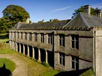
Godolphin House
Tregonning Hill (596 feet) and Godolphin Hill (495 feet) are in the parish. On the top of the former are the remains of a large Iron Age fort, believed to be of a Celtic chief named Conan (Gonan). It appears to have been of great strength, and was one of the largest on Cornwall. The granite on Tregonning was of two types: one was used for ornamental building under the name of Breage stone; the other, abounding in talc, was worked as china clay. William Cooksworthy discovered china clay here in the mid 18th century. There is also an old brick making works here.
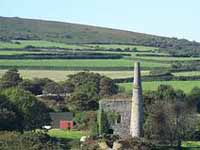
Polrose Tin Mine
Besides the Churchtown the principal villages of the parish are: Ashton, Trew, Praa Sands, Rinsey, Kenneggy, Hendra, Tregunno, Trescowe, Trevurvas, Herland (where the Goldolphin church stood), Carleen and Godolphin Cross.
The fishing village of Porthleven was partly in the parish and partly in Sithney. The new parish of Porthleven was created from parts of the parish of Breage in 1846.